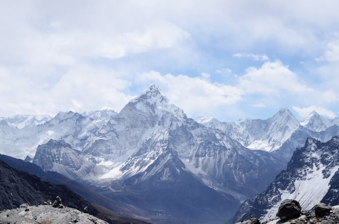
Spanning 80 km+ of continuous above-timberline trail and over 6,500 m total ascent, the Făgăraș Main Ridge remains the longest high-altitude ridge hike in Romania, offering 360° Carpathian panoramas and the summit of Moldoveanu Peak (2,544 m) – the highest point in the country.
This guide incorporates 2026 route updates, real rescue data, and gear recommendations tested on the ridge.
Is This Trail for You?
- Best suited for: fit backpackers carrying light tents & water filters
- Do NOT attempt if: you have no alpine or multi-day experience; rescue is 1–3 h by helicopter at best.
When to Go
| Season | Dates | Risk Level | Notes |
|---|---|---|---|
| Optimal | July–September | Low | Dry ridge, long days, safe snow bridges melted. |
| Shoulder | Early June, Oct (first half) | Medium | Possible late-season snow, storms common. |
| Avoid | Late October–May | High | Avalanche danger, winter rescues. |
Getting There
East Start (Plaiul Foii / Zărnești):
GPS: 45.553° N, 25.363° E. Zărnești is 11 km gravel road, 35 min 4×4 from town car park. Start early; free overnight parking available.
West End (Turnu Roșu):
GPS: 45.666° N, 24.350° E. Train/bus from Brașov daily. Ends with 4 km asphalt; pick-up advised.
15 Section Breakdown (East ➞ West)
Each section ends at a reliable spring or stream. Carry minimum 2 L between sources.
- S1 Cantonul Rudarița → Comisu – 7.8 km, +1 045 m, rugged forest ➞ alpine
- S2 Comisu → Curmătura Brătilei – 8.5 km, +320 m, wide grassy ridge, spring N.25 m below.
- S3 Curmătura Brătilei → Viștea Mare – 6.4 km, +450 m, exposed crest
- S4 Viștea Mare → Podu Giurgiului – 6 km, +530 m, -559 m.
- S5 Podu Giurgiului → Capra – 5.5 km, +48 m, -470 m.
- S6 Capra → Călțun – 6 km, +460 m, -550 m.
- S7 Călțun → Negoiu – 4 km, +350 m, -500 m.
- S8 Negoiu → Scara – 3.5 km, +420 m, -300 m.
- S9 Scara → Avrig – 3 km, +180 m, -300 m.
- S10 Avrig → Șaua Suru – 5 km, +340 m, -260 m.
- S11-S15 Descent to Turnu Roșu – Long descent through forest.
Moldoveanu Detour (+1 h)
- Turn-off after Podu Giurgiului, marked stone cairns.
- Summit register locked box at 2544 m; sign the QR-linked digital notebook.
- Exposed 40 m scramble – poles recommended only uphill.
2026 Safety Updates
Emergency Toolkit
- Salvamont Făgăraș: +40 268 310 122 or SMS 112 (automatic GPS pinpoint).
- Recent Incident (Oct 2025): 2 hikers evacuated by Brașov helicopter after slipping on wet rock near Netedu Peak.
Bear Safety
Carry bear spray in ridge pockets from S4 onward (bear territory confirmed). Discharge distance: 7 m; practice before leaving Zărnești.
Gear Specs (2026 Kit)
| Item | Must-Have | Notes |
|---|---|---|
| Tent | 4-season, 2 kg max | Wind-tested to 60 km/h recommended. |
| Sleeping | bag rated –5 °C comfort | Nights can drop to +2 °C even in July. |
| Water | 2×1 L bladders + filter | Critical for water-scarce sections. |
| Electronics | Garmin InReach / Powerbank | SOS button proven to cut rescue time significantly. |
Leave No Trace
Carry-out: toilet paper, wet-wipes, micro-plastics. Use the trash-bag-in-pocket method – easier than carrying a separate bag on narrow crests.
Citește și: transfagarasan-the-ultimate-mountain-road-hiking-guide • day-trips-from-sibiu-outdoor-adventures-in-the-southern-carpathians